The Spelling of the Village Name
The following is an article from the Somerset and Wiltshire Journal published on Friday 23rd May 1919:
ROAD – Changing the name of the village. – In opening proceedings, Mr Stokes gave many instances of vexatious delays and losses that had arisen, and stated that scarcely a week passed without complaints reaching him, as sub-postmaster, of letters or telegrams that had gone astray. – Rev. R. W. Baker confirmed Mr. Stokes’ statement, and said, although Road was the accepted telegraphic address, he had recently had the greatest difficulty in persuading a clerk in a distant town, when he handed in a telegram address Tellisford, Road, that he had not omitted the name of the village. Mr. P. Fussell told of a similar experience over the telephone, and Mr. Holdway gave an instance of a telegram sent to him from Bournemouth addressed Holdway, Woolverton, Road, which never reached him. On enquiries being made, it was found that the messenger had been to every house in Woolverton-road, Bournemouth, in search of a person named Holdway. Mrs. Batten Pooll said she had been looking up the historical records of the district, and had found that up till 1730 the name of the village was spelt Rode. No record could be found as to when the change took place, but when the parishes of Road and Woolverton were united, in the Ecclesiastical Records the name was spelt Rode ….. the following resolution was proposed by Mr. P. Fussell, seconded by Mr. T. Goulter, and carried unanimously:- “This meeting considers it desirable in the future interests of the village to revert to the ancient spelling of the name Rode, and requests the parish council to take the necessary steps to bring about the change.”
The name was changed to Rode by an order of Somerset County Council on 30th August 1919.
Based on documents written at the time it would appear that the spelling of village name changed from Rode to Road gradually over the period 1700 to 1730
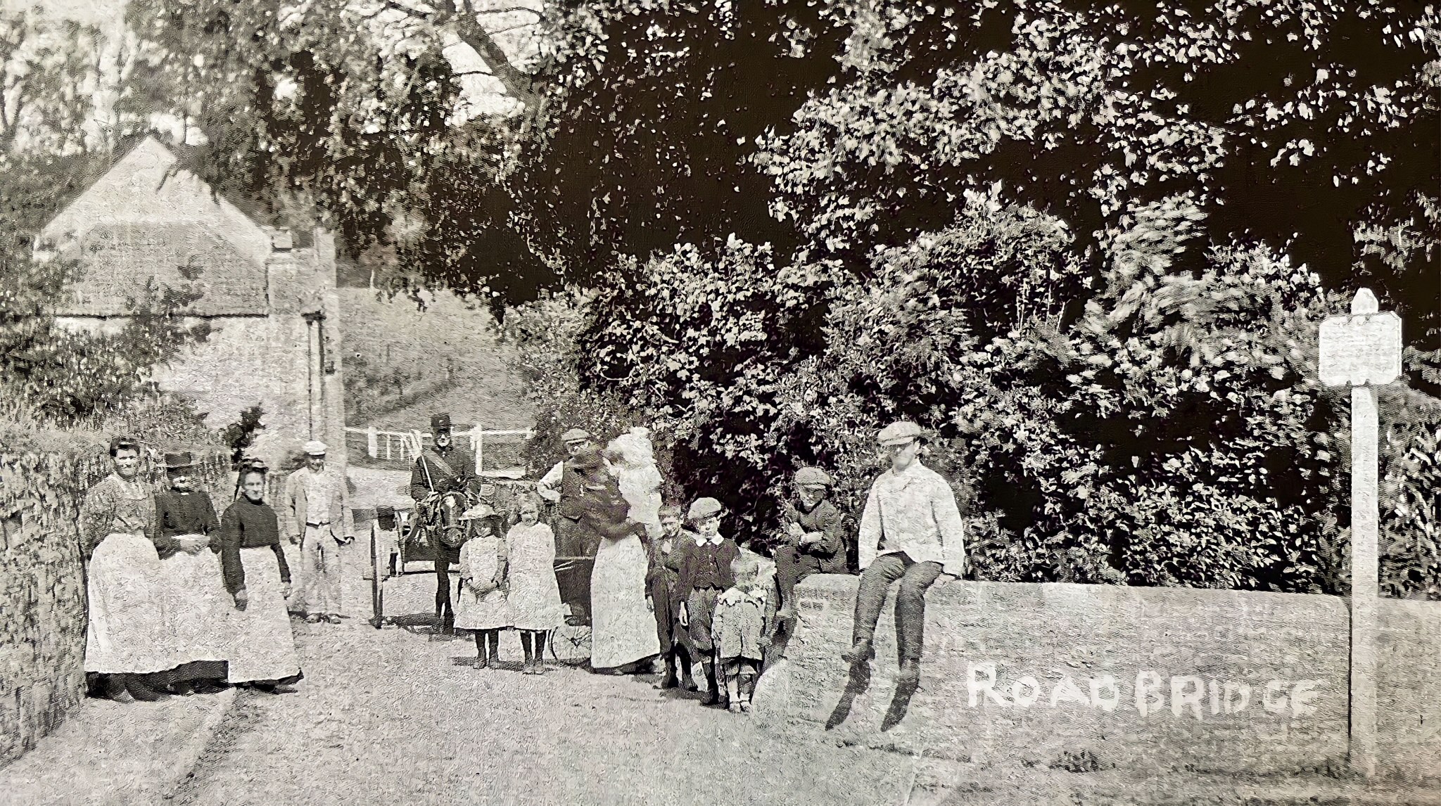
Where the name “ROAD” can still be seen
1. The parish boundary stone in the refuge at the centre of Rode Bridge. The front of the stone has a vertical line down its centre with N BRADLEY written on the east (Rode) side and ROAD on the west (Woolverton) side.
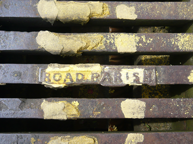
2. Road drain covers in High Street:
a. Outside Merfield Lodge – ‘ROAD SEWERS’
b. Outside no. 14 – ‘ROAD PARISH’
c. Outside no. 17b – ‘ROAD PARISH’
d. Junction with Church Lane – ‘ROAD PARISH’
e. Top of the Shard – ‘ROAD PARISH’
f. Outside no. 28 – ‘ROAD PARISH’
g. On the Green, opposite no. 57 – ‘SEWERS’/’ROAD’
3. Road drain covers elsewhere:
a. Outside no. 2 Marsh Road – ‘ROAD’/’SEWERS’
b. Junction of Church Lane/Nutt’s Lane – ‘ROAD PARISH’
c. Norton St. Philip outside Church Cottage, junction of Church Street and Vicarage Lane,
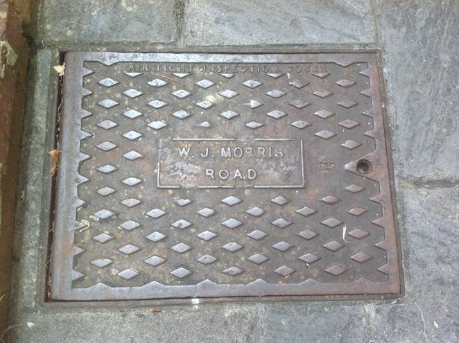
4. Airtight inspection covers
a. 2 in courtyard in front of Poppy Cottage, off the High Street – W. J. MORRIS/ROAD
Past Names of Places in Rode
(derivation) and possible locations
Back Street – Lower Street
Bath Street
Brassknocker Inn
Brown’s Lane (1792 map) – A361 from Bradford Road junction towards Frome Church Row – Frome Road
Champions Barton (1692 rent survey)
Cottage Lane
Crow Elm
Fives Court (1792 map) – top of Rode Hill near Pucks Well
Fore Street
Frog Street (1609 and 1692 rent surveys) – Lower Street
Goulter’s Barton 1891 census
Green Park
Gunston’s Barton – Cheap Street
Hoot A. Hse
Kelson’s House (1609 rent survey)
Lower House (1692 rent survey)
Millhouse Tanhouse (1692 rent survey) – Townsend
Mogg Hill (1805 map) – lower part of Rode Hill
Naish’s Lane/Barton –
New Town – 29 to 33 Church Lane
Park Street – Church Lane between the High St. and Nutts Lane
Paviour’s Well Barton – off Townsend Street 1891census
Poor House Lane – Marsh Road pre 1800
Pound (1792 map) –the village green
Pound Road (1792 map) – the High St. from the Green to Rode Hill
Prospect Place
Puck’s Well (1792 map) –on B on A road near top of Rode Hill
Road Bridge Road (1792 map) – Rode Hill
Rode heath (1609 rent survey) – Rode Common
Rode Lurke (1609 rent survey)
Scutts Bridge Lane (1609 rent survey) – Rockabella Lane
Shalford/Shoalford/Sholford (1609 and 1692 rent surveys) – Shawford
SidneyAlley – possibly the alley just south of the George Inn
Sitnah Place
Tennes Court (1773 map) – top of Rode Hill near Pucks Well
Three Horseshoes Inn – near junction of Marsh Rd. and Nutt’s Lane – possibly reuse of White Hart Inn
Townsend Street – High St. from Lower St. to The Mead
Town of Rode (1609 rent survey)
Upper House (1692 rent survey)
Upper Street – High Street from Lower Street the Green pre 1881
Whiteway Hundred (1609 and 1692 rent surveys)
Wilson’s Barton/Yard – off Townsend Street 1891census
Woodbine Cottage – at the junction of Church Lane and Clay Lane